
Worldview-3
WorldView-3 is the latest satellite sensor from DigitalGlobe. With the addition of this sensor to its satellite constellation (in addition to QuickBird, WorldView-1, GeoEye-1, Ikonos and WorldView-2), DigitalGlobe will be capable of collecting ~1 billion km2 of Earth imagery per year. DigitalGlobe has added a SWIR (Shortwave Infrared) sensing 8-band instrument to WorldView-3 satellite that will open up a host of new civil and military applications.
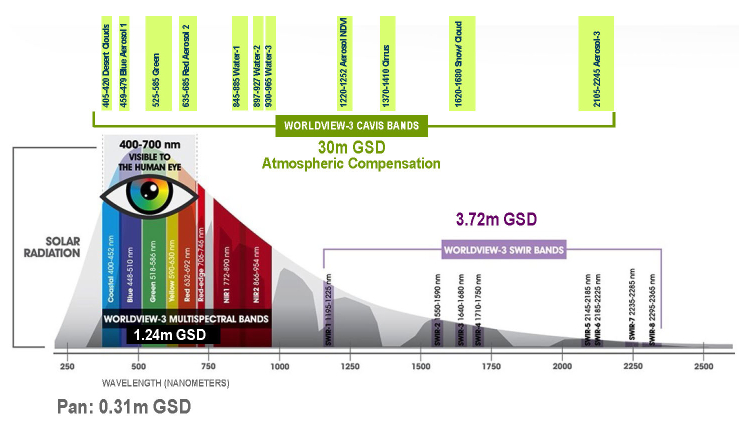
WorldView-3 provides 31 cm panchromatic resolution, 1.24 m MS (Multispectral) resolution, 3.7 m SWIR (Short-Wave Infrared) resolution, and 30 m CAVIS ( Clouds, Aerosols, Vapors, Ice, and Snow) resolution. CAVIS will monitor the atmosphere and provide correction data to improve WorldView-3′s imagery when it images earth objects through haze, soot, dust or other atmospheric particles. WorldView-3 builds upon WorldView-2 and WorldView-1 technology by carrying forward the satellites’ advanced Control Moment Gyroscopes (CMGs). CMGs reorient a satellite over a desired collection area in 4-5 seconds, compared to 30-45 seconds needed for traditional reaction wheels(QuickBird e.g.).
Sensor specifications
| Panchromatic | Panchromatic: 450 – 800 nm |
|---|---|
| Multispectral (8 Bands) | Coastal : 400 – 450 nm |
| Blue : 450 – 510 nm | |
| Green : 510 – 580 nm | |
| Yellow : 585 – 625 nm | |
| Red : 630 – 690 nm | |
| Red Edge : 705 – 745 nm | |
| Near-IR1 : 770 – 895 nm | |
| Near-IR2 : 860 – 1040 nm | |
| SWIR Bands (8 Bands) | SWIR-1 : 1195 – 1225 nm |
| SWIR-2 : 1550 – 1590 nm | |
| SWIR-3 : 1640 – 1680 nm | |
| SWIR-4 : 1710 – 1750 nm | |
| SWIR-5 : 2145 – 2185 nm | |
| SWIR-6 : 2185 – 2225 nm | |
| SWIR-7 : 2235 – 2285 nm | |
| SWIR-8 : 2295 – 2365 nm | |
| CAVIS* Bands(12 Bands) | Desert Clouds : 1195 – 1225 nm |
| Aerosol-1 : 405 – 420 nm | |
| Green : 459 – 509 nm | |
| Aerosol-2 : 525 – 585 nm | |
| Water-1 : 845 – 885 nm | |
| Water-2 : 897 – 927 nm | |
| Water-3 : 930 – 965 nm | |
| NDVI-SWIR : 1220 – 1252 nm | |
| Cirrus : 1350 – 1410 nm | |
| Snow : 2105 – 2245 | |
| Aerosol-3 : 1620 – 1680 nm | |
| Aerosol-3 : 2105 – 2245 nm |
WorldView-3 has following other Design and Specification features. Particularly interesting are highest Pan resolution of 0.31m, 30m CAVIS bands and a locational accuracy of 3.5m CE90 comparable to the GeoEye-1
| Orbit | Altitude: 617 km |
|---|---|
| Type: SunSync, 1:30 pm descending Node | |
| Period: 97 min. | |
| Life | Spec Mission Life: 7.25 years |
| Estimated: Service Life: 10 to 12 years | |
| Sensor Resolution | Pan Nadir: 0.31 m(20° Off-Nadir: 0.34 m) |
| Multispectral Nadir: 1.24 m(20° Off-Nadir: 1.38 m) | |
| SWIR Nadir: 3.70 m(20° Off-Nadir: 4.10 m) | |
| CAVIS Nadir: 30.00 m | |
| Dynamic Range | 11-bits per pixel Pan and MS |
| 14-bits per pixel SWIR | |
| Swath Width | At nadir: 13.1 km |
| Attitude Determination and Control | Type: 3-axis Stabilized |
| Actuators: Control Moment Gyros (CMGs) | |
| Sensors: Star trackers, precision IRU, GPS | |
| Pointing Accuracy and Knowledge | Accuracy: <500 m at image start/stop |
| Knowledge: Supports geolocation accuracy given below | |
| Retargeting Agility | Time to Slew 200 km: 12 sec |
| Max Contiguous Area Collected in a Single Pass (30° off-nadir angle) | Mono: 66.5 km x 112 km (5 strips) |
| Stereo: 26.6 km x 112 km (2 pairs) | |
| Revisit Frequency (at 40°N Latitude) | 1 m GSD: <1.0 day |
| 4.5 days at 20° off-nadir or less | |
| Geolocation Accuracy(CE90) | Predicted <3.5 m CE90 without ground control |
| Capacity | 680,000 km2 per day |
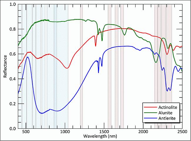
As we can see from the table shown above, WorldView-3 sensor allows observation of a much wider range of the electromagnetic spectra than most other commercial satellites, and will allow the data user to start looking for the individual spectral signatures of materials. Below figure shows the spectral signatures of three minerals. The light blue regions on the plot denote the VNIR bands covered by Worldview-2and WorldView-3. The light red regions denote the SWIR bands covered by the 8 new WV-3 bands. This shows just how much further the new bands penetrate into the electromagnetic spectrum. The spectral profiles of each pixel in an image can be compared to a spectral library (such as the reflectance spectra shown) to classify what material is contained within that pixel.
This type of automated spectral classification allows us to remotely monitor materials and is invaluable to a great number of industries for example in forestry applications where we see users wanting to monitor tree health and pest infestation in remote regions. WorldView-3 brings a limited version of this capability to users at a reduced price, so one still can’t expect the accuracy of a hyperspectral satellite, but it really is a step beyond the features we could extract from multispectral data. Digital Globe’s marketing refers to this observation scheme as ‘super-spectral’.
CAVIS ( Clouds, Aerosols, Vapors, Ice, and Snow): The CAVIS imager is provided by Ball Aerospace & Technologies Corporation (BATC). The objective of CAVIS is to monitor the atmosphere and provide correction data to improve WorldView-3′s high-resolution imagery when it images Earth objects through haze, soot, dust or other obscurants. The CAVIS imager has a resolution of 30 m.
The CAVIS instrument brings an unprecedented level of consistency in data, paving the way to standardization of satellite imagery. CAVIS corrects for the inconsistencies caused by certain conditions, offering standardized imagery no matter where or when the data was captured. This standardization will introduce a new age of automated information extraction and feature detection.
Below shown animation portrays application of WorldView-3 imagery in identification of various minerals using ‘mineral indices’.
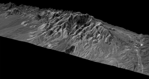
Application to Mineral Exploration (Image Credit: DigitalGlobe)