GST offer Airborne Hyperspectral and Thermal Imaging Sensor products, imaging services and solutions for a variety of applications, including search and rescue, heat loss, coastal mapping, forestry, agriculture and environmental monitoring. We also offer a range of products to provide our clients with a complete hyperspectral imaging solution tailored to their needs.
Our specializations are:
End-to-end advanced airborne imaging sensor design (optics, electronics, software, calibration, real-time and remote-operation hardware, etc.) utilizing patented and proprietary technologies
Providing airborne hyperspectral and broadband surveying (mission planning, mobilization, data collection, data product delivery, etc.) from small (< 1.0 square km) to very large (> 20,000 square km) areas
Custom image analysis product and algorithm development
GST offers COTS and custom sensor systems utilizing diffraction-limited optics and detectors spanning the near-UV through to the LWIR
TABI-1500
The TABI-1800 is a thermal broadband imager which follows the same philosophy as the TABI-320 while offering new technologies which improve sensitivity and increase the swath from 320 pixels to 1800 pixels.
Learn more
CASI-1500
The CASI-1500 is a visible near Infrared (VNIR) sensor which offers an impressive 1500 pixels across its field of view, allowing you to image a vast area with a single pass, or achieve spatial resolutions as high as 25 cm using a standard fixed-wing aircraft.
Learn more
SASI-1000A
The finest hyperspectral SWIR imaging system available today, ITRES’ SASI-1000A offers 100 bands of low noise, high fidelity imagery over the short-wave infrared spectrum.
Learn more
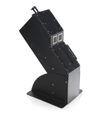
MASI-600
The MASI-600 is the first commercially available Midwave hyperspectral sensor designed specifically for airborne use. As with all of our sensors, the MASI-600 has custom designed optics which provide extremely sharp imagery and precise spectral resolution. This sensor also has a high signal to noise ratio due to the stirling cycle cooled MCT (mercury cadmium telluride) detector.
Learn more
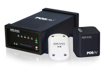
"Applanix POS AV System
The POS AV (Position Orientation System) is a hardware and software system specifically designed for direct georeferencing of airborne sensor data. By integrating precision GPS with inertial technology, POS AV enables geospatial projects to be completed more efficiently, effectively, and economically.
Learn more
Precision Geocor System
As the final program run in the ITRES Standard Processing chain, Geocor geometrically corrects sensor image data by mapping it onto a chosen coordinate system (e.g. UTM).
Learn more
Calibration System
Every ITRES instrument is radiometrically calibrated to exacting specifications before we ship it to you, so that you can have complete confidence in the accuracy of your sensor.
Learn more
Real-Time Processing System
Every ITRES instrument is radiometrically calibrated to exacting specifications before we ship it to you, so that you can have complete confidence in the accuracy of your sensor. We recommend that your imager be re-calibrated once per year (a service which is included with our Comprehensive Service Plan).
Learn more
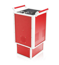
MuSIC System
The optional MuSIC system permits the simultaneous operation of up to three ITRES hyperspectral imaging sensors using a single Instrument Control Unit (ICU), sunlight-readable video display (high altitude version available), KVM1 switch, and software controller.
Learn more
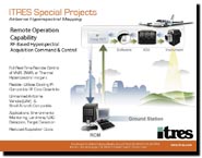
Remote Operation Capability
With the introduction of remote radio frequency (RF) down-link capability, ITRES again pushes the operational capabilities of commercial airborne hyperspectral mapping to a new frontier.
Learn more
Airworthiness Certification
TRES has developed expertise in the area of Airworthiness Certification. In cooperation with our aeronautical engineering and testing facility partners, we can offer various levels of support to help you achieve certification for you sensor system installation
Learn more
Hyperspectral Image Analysis
for Orthocorrection Digital Terrain Models (DTMs) from Lidar (Light Detection and Ranging) or IFSAR (Interferometric Synthetic Aperture Radar) sources are used to orthocorrect hyperspectral imagery from ITRES sensors.
Learn more

.jpg)