
Landsat ETM+ Gap-Filled
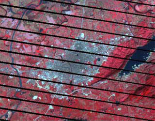
Some of the most popular and valued remote sensing images of the earth are obtained from the Landsat satellites which have been orbiting the earth for over thirty years. Prior to the launch of Landsat 7, two Landsats were in operation – Landsat 4 (operating from 1982 to decommission in June 2001) and Landsat 5 (operating since March 1984). Landsat 7 has been operating from 1999. Unfortunately on 31 May 2003 there was a malfunction of the Scan Line Corrector Mechanism on Landsat 7 resulting in gaps and repetitions in the imagery.
Specifications
| Resolution | Panchromatic: 15m |
|---|---|
| Multispectral ETM+: 30m | |
| Nominal Swath Width | 183 km at Nadir |
| Bands | 8 Bands (Thermals repeats as 6-1 and 6-2) |
| Archive Availability (Gap-Free, SLC-on) | From 1999 to March 2003 |
| Archive Availability (With Gaps, SLC-off) | From March 2003 |
| Gap Filling Option | Using Pre-2003 SLC-on Gap Free imagery |
| Using SLC-off, temporally similar imageryy | |
| Programmability | NO |
| Minimum Area of Purchase | One full scene |
| 100 sqkms for New Collect imagery | |
| Stereo Available | NO |
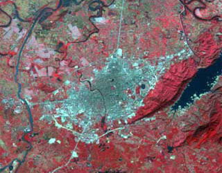
Gap Filling Solution:
Our Landsat Gap-Filled series of products are created with advance image processing algorithms that give near gap-free appearance to the filled scene.
Customers can choose from following methods of Gap-Filling:
- SLC-off to SLC-on
- SLC-off to SLC-off
In this method the SLC-off scene is filled using a SLC-on scene of similar temporal parameters.
This method gives near-complete fill of the primary scen
In this method SLC-off scene choosen from closest possible dates are used to fill the gaps in the SLC-off primary scene. Upto 4 ‘fill’ scenes are used in this method. Anytiny slivers are filled later by an SLC-on scene.