
SPOT
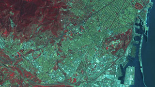
SPOT-5 is the fifth satellite in the SPOT series of CNES (Space Agency of France), placed into orbit by an Ariane launcher. Since the first SPOT satellite was launched in 1986, the SPOT system has sought to provide continuity of service and constantly improved the quality of its products for the global user community.SPOT 5 is capable of up to 2.5-meter and 5-meter panchromatic and 10-meter multispectral. SPOT 5 is particularly well suited for timber, vegetation and geological applications with its short wave infrared (SWIR) band.
Specifications
| Resolution | Panchromatic : 2.5 m or 5 m (at nadir) |
|---|---|
| Multispectral: 10 m (at nadir) | |
| Nominal Swath Width | 60 km at Nadir |
| Bands | Pan: 480-710 nm |
| Green: 500-590 nmm | |
| Red: 610-680 nm | |
| Near IR: 780-890 nm | |
| Short Wave Infrared: 1.58-1.75 μm | |
| Archive Availability | From 2002 |
| Programmability | YES |
| Minimum Area of Purchase | 1/8th of a scene (20 x 20 kms) |
| 100 sqkms for New Collect imagery | |
| Stereo Available | YES |
| Best Scale | 1:10,000 – (Panchromatic) |
| 1:10,000 – (Pan-sharpened Multispectral) | |
| 1:40,000 – (Multispectral) |
SPOT 1-4
SPOT 1, 2, 3 and 4 are high resolution satellites that were launched in 1986, 1990, 1993 and 1998 respectively. The satellites captured both panchromatic (black & white) and multispectral (colour) digital imagery. SPOT 4 & SPOT 5 are the only active satellites in this constellation at the moment. The data acquired by these satellites provides valuable insights in the form of historical satellite imagery. SATPALDA can provide historical imagery from these sensors at 10m B&W resolution and 20m color resolution.