
DMC
The Disaster Monitoring Constellation (DMC) consists of Algerian, Nigerian, Turkish, British and Chinese remote sensing satellites constructed by Surrey Satellite Technology Ltd (SSTL) and operated by DMC International Imaging. The main aim of this constellation is disaster relief under the International Charter for Space and Major Disasters. DMC Earth imagery is used for a variety of civil applications by a variety of governments. Idle imaging capacity is utilized for commercial purposes.
Below are the sensors which form part of this constellation:
| Satellite | Sensor | Resolution |
|---|---|---|
| AlSat-1 | SLIM-6 | 31.822 m |
| Beijing-1 | SLIM-6 | 31.822 m |
| Deimos-1 | SLIM-6-22 | 22.001 m |
| NigeriaSat-1 | SLIM-6 | 31.822 m |
| UK-DMC | SLIM-6 | 31.822 m |
| UK-DMC2 | SLIM-6-22 | 22.001 m |
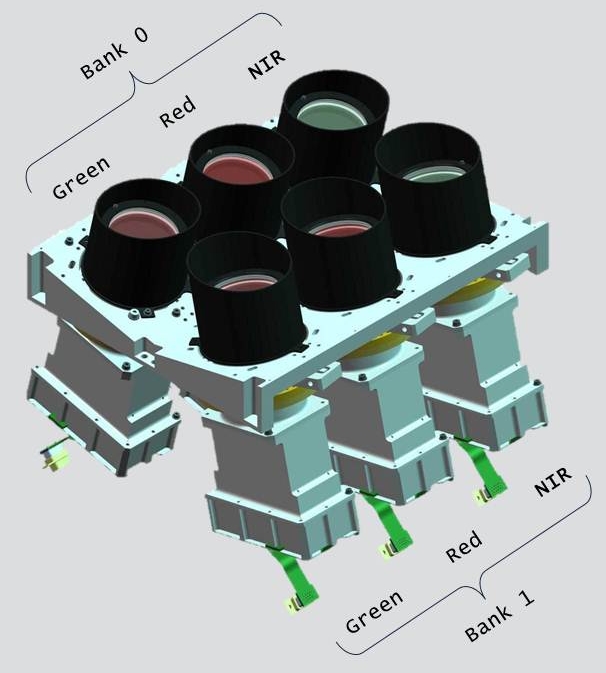
Out of these UK-DMC, Nigeriasat-1, and Alsat-1 have been retired. New Satellite have been launched under DMC-2 constellation named as Nigeriasat-2 and UK-DMC2. The primary imaging payload on-board these satellites is the SLIM-6 class imager built by SSTL UK. The design of the SLIM-6 class imagers provides a 3 spectral bands.
The spectral band selection for the DMC spacecrafts was deliberately chosen to be equivalent to that of the SPOT HRV multi-spectral imagers and bands 2, 3 and 4 of the LANDSAT Thematic Mapper.
Previous satellites have used these bands in a multitude of application areas from land-use classification, crop yield assessments and vegetation stress monitoring, to burn scar mapping, urban growth modeling and insect threat assessment. However, the unique combination of high-swath, medium-spatial resolution and high-temporal resolution of the DMC opens up a new range of application areas: The system is found to be ideal for monitoring the development of fire risk over very short temporal scales using a combination of scene-derived vegetation indices, classification maps and external thermal data.
SLIM – 6 Sensor Specifications
| Sensor | Eastman Kodak KLI-10203 |
|---|---|
| Linear CCD: | |
| Number of Detectors = 10,2243 | |
| Detector Size = 7.0 µm x 7.0 µm | |
| Data Capture = 11-bit | |
| Lens | Schneider Apo-Componon HM 150mm focal length, f/6.3 |
| Focal length = 150.9 mm | |
| F-number = f/6.3 | |
| iFoV (Instantaneous Field of View) | 46.388×10⁻⁶ rad = 0.00266° = 9.568 arc sec |
| GSD | 31.822 meter at nadir |
| Swath | 324.58 km |
| Spectral Bands | |
| Red: 0.63 – 0.69 μm (Equivalent to Landsat ETM+ 3) | |
| Green: 0.52 – 0.60 μm (Equivalent to Landsat ETM+ 2) |
SLIM–6–22 Sensor Specifications
| Sensor | Eastman Kodak KLI-14403 Linear CCD: |
|---|---|
| Number of Detectors = 14,436 | |
| Detector Size = 5.0 µm x 5.0 µm | |
| Data Capture = 14-bit | |
| Lens | Custom designed double Gaussian derivative lens |
| Focal length = 155.9 mm | |
| F-number = f/53 | |
| iFoV (Instantaneous Field of View) | 32.1×10⁻⁶ rad = 0.00184° = 6.62 arc sec |
| GSD | 22.001 meter at nadir |
| Swath | 340.00 km |
| Spectral Bands | NIR: 0.77 - 0.90 µm (Equivalent to Landsat ETM+ 4) |
| Red: 0.63 – 0.69 µm (Equivalent to Landsat ETM+ 3) | |
| Green: 0.52 – 0.60 µm (Equivalent to Landsat ETM+ 2) |
Applications:
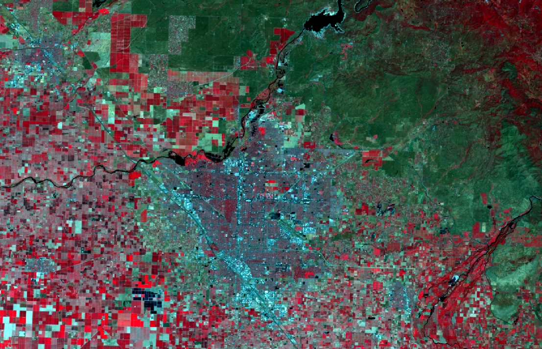
The daily revisit and flexible image format of the DMC proved invaluable in obtaining timely image data following the October 2003 floods in Vietnam. Erosion due to flooding/hydrology was also monitored in Nigeria and Morocco. Following the 2004 Asian tsunami, the DMC was able to quickly image the coastlines of the affected countries and map out the damage caused.
Fire monitoring and automatic fire scar evaluation has also proven to be viable, with particularly impressive results following forest fires in Alaska, Algeria and Nigeria. For the Alaskan fire, we estimated a burn-scar area of 5,007 acres based on DMC imagery. This was in good agreement with the US Geological Survey estimate of 5,600 acres based on ground samples.
DMC image data was compared to that from SPOT 5 and LANDSAT to determine the feasibility of automatic land-use classification for agriculture and urbanisation studies. It was found that the DMC images gave the same results as LANDSAT. DMC data has already found application in agricultural monitoring, urban development mapping, geological and hydrological mapping.