
Airborne Hyperspectral & Thermal Imagery
"Applanix POS AV System
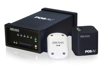
The POS AV (Position Orientation System) is a hardware and software system specifically designed for direct georeferencing of airborne sensor data. By integrating precision GPS with inertial technology, POS AV enables geospatial projects to be completed more efficiently, effectively, and economically.
Learn more
Precision Geocor System

As the final program run in the ITRES Standard Processing chain, Geocor geometrically corrects sensor image data by mapping it onto a chosen coordinate system (e.g. UTM).
Learn more
Calibration System

Every ITRES instrument is radiometrically calibrated to exacting specifications before we ship it to you, so that you can have complete confidence in the accuracy of your sensor.
Learn more
Real-Time Processing System
Every ITRES instrument is radiometrically calibrated to exacting specifications before we ship it to you, so that you can have complete confidence in the accuracy of your sensor. We recommend that your imager be re-calibrated once per year (a service which is included with our Comprehensive Service Plan).
Learn more
MuSIC System
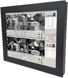
The optional MuSIC system permits the simultaneous operation of up to three ITRES hyperspectral imaging sensors using a single Instrument Control Unit (ICU), sunlight-readable video display (high altitude version available), KVM1 switch, and software controller.
Learn more
Remote Operation Capability
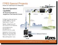
With the introduction of remote radio frequency (RF) down-link capability, ITRES again pushes the operational capabilities of commercial airborne hyperspectral mapping to a new frontier.
Learn more
Airworthiness Certification
TRES has developed expertise in the area of Airworthiness Certification. In cooperation with our aeronautical engineering and testing facility partners, we can offer various levels of support to help you achieve certification for you sensor system installation
Learn more
Hyperspectral Image Analysis
for Orthocorrection Digital Terrain Models (DTMs) from Lidar (Light Detection and Ranging) or IFSAR (Interferometric Synthetic Aperture Radar) sources are used to orthocorrect hyperspectral imagery from ITRES sensors.
Learn more