
GeoEye-1

The GeoEye-1 satellite, launched on September 6, 2008, collects images at nadir with 0.41-meter panchromatic and 1.65-meter multispectral resolution. (Imagery sold to commercial customers is resampled to 0.5-meter resolution.) Just as important, 3 meters of inherent geolocation accuracy has never before been achieved in any commercial imaging system.
Originally named OrbView-5, GeoEye-1 has proven to be a milestone in the area of commercial imaging. The satellite collects up to 700,000 square kilometers of panchromatic (and up to 350,000 square kilometers of pan-sharpened multispectral) imagery per day. GeoEye-1 is able to revisit any point on Earth once every three days or sooner.
After the merger of GeoEye with DigitalGlobe, the satellite has joined WorldView-1, WorldView-2, QuickBird under unified umbrella constellation of DigitalGlobe. Ikonos too has joined its ranks.
Specifications of GeoEye-1 sensor:
| Launch Date | September 6, 2008 |
|---|---|
| Camera Modes | 0.41 m / 1.34 ft Panchromatic at nadir |
| 1.65 m / 5.41 ft* multispectral | |
| Spectral Range | Panchromatic: 450 – 800 nmBlue: 450 – 510 nm |
| Green: 510 – 580 nm | |
| Red: 655 – 690 nm | |
| Near Infra Red: 780 – 920 nm | |
| Accuracy | CE stereo: 2 m / 6.6 ft |
| LE stereo: 3 m / 9.84 ft | |
| CE mono: 3.5 m / 8.20 ft | |
| These are specified as 90% CE (circular error) for the horizontal and 90% LE (linear error) for the vertical with no ground control points (GCP’s). | |
| Swath Width | Nominal swath width – 15.2 km / 9.44 mi at Nadir |
| Single-point scene – 225 sq km (15×15 km) | |
| Contiguous large area – 15,000 sq km (300×50 km) | |
| Contiguous 1° cell size areas – 10,000 sq km(100×100 km) | |
| Contiguous stereo area – 6,270 sq km (224×28 km) | |
| (Area assumes pan mode at highest line rate) | |
| Imaging Direction | Capable of imaging in any direction |
| Collection Capacity | Up to 700,000 sq km/day (270,271 sq mi/day) of pan area |
| Up to 350,000 sq km/day (135,135 sq mi/day) of pan-sharpened multispectral area | |
| Dynamic Range | 11 bit per pixel |
platform technical Information:
| Launch Vehicle | Delta II |
|---|---|
| Launch Vehicle Manufacturer | Boeing Corporation |
| Launch Location | Vandenberg Air Force Base, California |
| Satellite Weight | 1955 kg |
| Satellite Storage and Downlink | 1 Terabit recorder; X-band downlink (at 740 mb/sec or 150 mb/sec) |
| Orbital Altitude | 684 kilometers / 425 miles |
| Orbital Velocity | About 7.5 km/sec or 17,000 mi/hr |
| Inclination/Equator Crossing Time | 98 degrees / 10:30am |
The GeoEye-1 satellite is in a sun-synchronous orbit with a nominal equator crossing at 10:30 AM local. It takes approximately 98 minutes to complete one orbit and it makes nearly 15 orbits per day. The relatively high orbit, at 684 km above the Earth’s surface, allows for more access time over a particular area of interest resulting in larger collection capacity.
Comparison with other sensors:
Smaller Ground Sample distance allows GeoEye-1 to acquire high quality imagery even at high off-nadir angles.
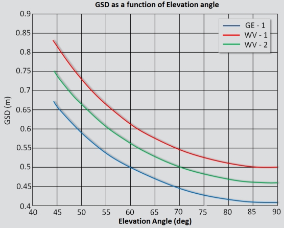
Small GSD at low elevation angles is also important for shorter revisit times. This important factor makes GeoEye-1 the only sensor to achieve a GSD of 50cm even at Off-nadir angles as low as 60 deg(Off-nadir 30deg) unlike any other current or planned sensor.