
Ikonos
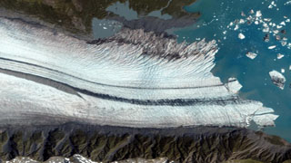
When GeoEye successfully launched the IKONOS satellite in 1999, it made history with the world’s first one-meter commercial remote sensing satellite. Moving over the ground at approximately seven kilometers per second, IKONOS collects black and-white and multispectral data at a rate of over 2,000 square kilometers per minute. Through the nearly fifteen, 98-minute journeys it makes around the globe each day, IKONOS collects vital statistics about the Earth’s ever-changing features—from fluctuations in land and water resources to the build-out of new urban areas.
Ikonos derives its name from the Greek term eikōn for image
Specifications of Ikonos sensor:
| Launch Date | 24 September 1999 Vandenberg Air Force Base, California |
|---|---|
| Operational Life | Over 8.5 Years |
| Orbit | 98.1 degree, sun synchronous |
| Speed on Orbit | 7.5 kilometers (4.7 miles) per second |
| Speed Over the Ground | 6.8 kilometers (4.2 miles) per second |
| Number of Revolutions Around the Earth | 14.7 every 24 hours |
| Orbit Time Around the Earth | 98 minutes |
| Altitude | 681 kilometers (423 miles) |
| Resolution | Nadir: |
| 0.82 meters (2.7 feet) panchromatic | |
| 3.2 meters (10.5 feet) multispectra | |
| 26° Off-Nadir : | |
| 3.2 meters (10.5 feet) multispectra | |
| 4.0 meters (13.1 feet) multispectral | |
| Spectral Range | Blue: 445–516 nm |
| Green : 506–595 nm | |
| Red : 632–698 nm | |
| NIR : 757–853 nm | |
| Pan : 450–900 nm | |
| Spectral Range | 11.3 kilometers (7.0 miles) at nadir |
| 13.8 kilometers (8.6 miles at 26° off-nadir) | |
| Equator Crossing Time | Nominally 10:30 a.m. solar time |
| Revisit Time | Approximately 3 days at 1-meter resolution, 40° latitude |
| Dynamic Range | 11-bits per pixel |
| Image Bands | Panchromatic, blue, green, red, near infrared |
IKONOS is a three-axis stabilized spacecraft designed by Lockheed Martin. The design later became known as the LM900 satellite bus system. The satellite’s altitude is measured by two star trackers and a sun sensor and controlled by four reaction wheels; location knowledge is provided by a GPS receiver. The design life is seven years; S/C body size=1.83 m × 1.57 m (hexagonal configuration); S/C mass = 817 kg; power = 1.5 kW provided by three solar panels.
Ikonos’ applicationss include both urban and rural mapping of natural resources and of natural disasters, tax mapping, agriculture and forestry analysis, mining, engineering, construction, and change detection. It can yield relevant data for nearly all aspects of environmental study.