
Hyperspectral Image Analysis software
Hyperspectral Plus Lidar: Fusing Spectral Profiling & Tarrain Modelling Captabilities
Hyperspectral + Lidar Data Fusion
for Orthocorrection Digital Terrain Models (DTMs) from Lidar (Light Detection and Ranging) or IFSAR (Interferometric Synthetic Aperture Radar) sources are used to orthocorrect hyperspectral imagery from ITRES sensors. Doing so removes terrain-related distortions, improving positional accuracy in the output imagery. DTM integration is accomplished using proprietary standard processing software. Lidar and IFSAR systems can be comounted with ITRES sensors for coincident data collection or data can be collected separately and fused in post-processing.
Fusion of hyperspectral and DTMs also allows for mapping drainage networks, potential transportation corridors, urban development, and line-of-sight analysis. When airborne imagery is draped over co-registered elevation models, a three-dimensional perspective of an area can be represented at small mapping scales.
Hyperspectral/Lidar Fusion Assists in Change Detection
Draping hyperspectral imagery over Lidar DTMs serves as an easy way to improve data visualization and interpretation. The images at left show VNIR CASI imagery draped over a Lidar DTM, before and after highway construction in Eddyville, Iowa.
Strengthening Spectral Identification with Terrain Modelling
Lidar and IFSAR DTMs are also used to augment the spectral discrimination power of hyperspectral imagery during analysis and product generation.
Project Details
- Lidar/IFSAR Fusion for:
- Image Orthocorrection
- Data Visualization
- Image Analysis
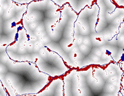
Wetlands probability product from CASI and Lidar analysis (darker color = higher probability). Data modelling by Mississippi State University, NCRST-E.