Worldview-1
WorldView-1 provides earth imagery at 50cm spatial resolution. Being a panchromatic(Black & White) sensor, WorldView-1 can acquire very large areas in short period of time. This sensor was launched by DigitalGlobe on September 18, 2007. With an average revisit time of 1.7 days, WorldView-1 is capable of collecting up to 750,000 square kilometers (290,000 sq mi) per day of half-meter imagery.
Worldview-1 specifications
| Launch Information | Date: September 18, 2007 |
|---|---|
| Launch Vehicle: Delta II 7920 | |
| Launch Site: Vandenberg Air Force Base | |
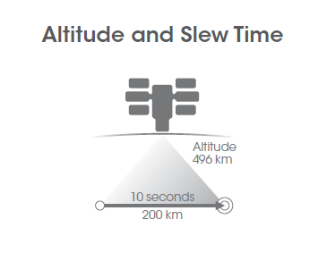
| Orbit | Altitude: 496 kilometers |
| Type: Sun synchronous, 10:30 am descending node | |
| Period: 94.6 minutes | |
| Sensor Bands | Panchromatic |
| Sensor Resolution (GSD = Ground Sample Distance) | 0.50 meters GSD at nadir |
| 0.59 meters GSD at 25° off-nadir | |
| NIIRS Equivalency | NIIRS potential of greater than 5.0 |
| DynamicRange | 11-bits per pixel |
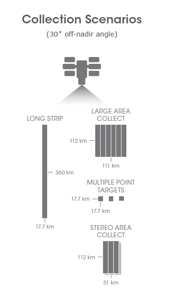
| Swath Width | 17.6 kilometers at nadir |
| Pointing Accuracy & Knowledge | Accuracy: <500 meters at image start and stop |
| Knowledge: Supports geolocation accuracy below | |
| Retargeting Agility | Acceleration: 2.5 deg/s/s |
| Rate: 4.5 deg/s | |
| Time to slew 300 kilometers: 10.5 seconds | |
| Onboard Storage | 2199 gigabits solid state with EDAC |
| Max Viewing Angle / Accessible Ground Swath | Nominally +/-45° off-nadir = 1036 km wide swath Higher angles selectively available |
| Per Orbit Collection | 331 gigabits |
| Max Contiguous Area Collected in aSinglePass | 60 x 110 km mono 30 x 110 km stereo |
| Revisit Frequency | 1.7 days at 1 meter GSD 4.6 days at 25° off-nadir or less (0.59 meter GSD) |
| Geolocation Accuracy (CE90) | Geolocation Accuracy specification of 6.5m CE90% at nadir, with actual accuracy in the range of 4.0 – 5.5m CE90%, excluding terrain and off-nadir effects |
Ball Aerospace provided its BCP 5000 spacecraft bus, and the WorldView 60(Similar to the one used by QuickBird sensor) camera for the commercial imaging satellite.A new feature of the WorldView-1 spacecraft are CMG (Control Moment Gyroscopes) actuators for precise and highly responsive pointing control. The BCP-5000 bus provides increased power, stability, agility, data storage and transmission (over the BCP-2000 bus) as the demand for Earth remote-sensing information becomes more comprehensive.
The S/C is 3-axis stabilized. The ADCS (Attitude Determination and Control Subsystem) employs star trackers, IRU (Inertial Reference Unit) and GPS for attitude sensing, and CMGs as actuators. A S/C body-pointing range of ±40º about nadir is provided corresponding to a FOR (Field of Regard) of 775 km in cross-track. An instantaneous pointing accuracy of ≤ 500 m is provided at any start and stop of an imaging sequence. On the ground, the geolocation accuracy of the imagery is 5.8 to 7.6 m without GPCs (Ground Control Points) and 2 m with GPCs (3σ). The agile S/C provides retargeting at a rate of 4.5º/s with an acceleration of 2.5º/s2; it takes 9 s to slew the S/C over a ground distance of 300 km.